
Texture Module
The Rhopoint Aesthetix Texture Module provides objective analysis of the surface characteristics critical to visual perception and quality control for textured surfaces.
Textured surfaces are those with irregular or patterned finishes, differing from smooth or flat surfaces. These textures can be natural or manufactured and include features like ridges, grooves, bumps, or grains that affect the material's tactile and visual properties.
Examples include:
Leather-like Surfaces: Found in automotive interiors and furniture, mimicking natural leather.
Coated Surfaces: Textured paint or powder coated surfaces on metal or plastic, influencing appearance and feel.
Plastic pars: Moulded textures in consumer electronics and automotive components for grip and aesthetics
Textured surfaces are crucial in many industries for their impact on product aesthetics, functionality, and consumer perception, such as automotive, powder coating and leather manufacture, ensuring enhanced quality control, product development, and consistency across global supply chains.
Using Aesthetix, the user can reduce subjective errors associated with visual inspection, ensuring measured surfaces have the required perceived quality and good harmony with adjacent parts.
Measurement Method
RGB colour, gloss, reflectivity, and 3D topography measurements are combined into a single measurement, delivering precise and repeatable results.
The Aesthetix uses utilizes photometric stereo techniques to estimate surface normals and calculate 3D topography, providing a detailed height map of the surface.
A watershed algorithm is then applied to segment the topography into cells, allowing for the analysis of cell size and area.
60° gloss is measured and reported, fully compliant with international norms ASTM D523 & ISO 2813.
RGB colour is measured using 45°:0° geometry and the reported values are calculated using the average RGB pixel value of the area captured by the observer camera.
Reflectance parameters are calculated using the gloss camera & reflectance differences measured using the observer camera.
Texture feature properties (watershed methodology)
Watershed Overview
To separate features on the surface, a so-called “watershed algorithm” is applied to the topographic height map.
A flooding analogy can be used to understand the watershed principle.
The measured topographical map can be treated like a landscape of hills and valleys.
When water is poured into the landscape, and the water level rises, the valleys (which are the local minima of the gradient image) start filling up with water, separating the hills as islands (“features”).
When water from two different valleys meet and merge, a dam (or watershed line) is constructed to prevent merging.
These watershed lines effectively become the boundaries between different regions in the image.
The result is a segmented image where each region is separated by watershed lines, corresponding to different features within the surface.
![Topographical height map]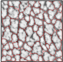
Topographical height map of a surface with watershed analysis applied
Control over how the watershed lines are constructed in Appearance Elements is given in the “Feature Properties” settings.